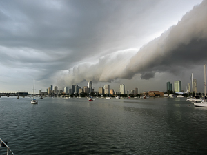
Line Squalls or Squall Lines
A line of thunderstorms that may form ahead of a quick moving cold front. They indicate the formation of heavy rain fall, strong winds, large hail and frequent lighting. They are also associated with tornadoes.
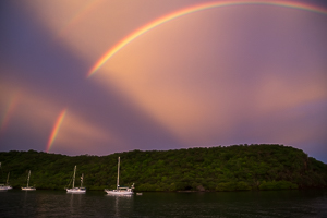
Caribbean Weather
There is no topic of more interest and importance to the cruising sailor than weather. With modern computer models and the Internet it is relatively easy to get the raw information and tailored forecasts, but making sense of the often conflicting information is always difficult.
Weather Resources
Raw Data
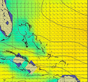
The most recent innovation to weather data has been the GRIB ( ) weather file. These files are produced by the various major weather models and models of waves and currents. Because of the standardized formats, they can be displayed by easy to use viewers. Passage Weather and zygrib are two of the most popular. Because it is easy to use many sailor rely on it. But care must be taken with a large grain of salt. First, they are untouched by human hands (or minds) so garbage in garbage out. Second, because of their resolution in both time and space, they often miss phenomena that are important to the Cruising Sailor.
Charts, Maps, and Pilot Atlases
These are the traditional sources of weather data for the sailor. They are produced by professional weather forecasters and represent their best guess. They even sign their name to their product. The Internet has made acquisition of these resources much easer. The most popular is the surface prog (prognosis) chart. These are available for the current conditions and 24 to 96 hours in the future in some regions. They were originally designed to be sent out by radio fax to receivers aboard ships. While they are still transmitted in this manner, they can be downloaded from the Internet.
Forecasts both printed and broadcast
The most well known weather broadcast for the Caribbean, is Chris Parker on Single Side Band. He has just upgraded his transmitters and now broadcasts to the Eastern Caribbean at 0700 AST on 8137 upper side band. He also provides by subscription the same information by email and by live conference on the Internet. Subscribers can call in and get detailed weather forecasts. His limitation is that the regions he forecasts are large and often glosses over local conditions.
Many of the islands have local forecasts broadcast on Channel 68 (or other) in the morning. The quality of these broadcasts varies from good to awful. They are prepared by volunteer forecasters who gather the information from the Internet.
NOAA as well as the Met (Meteorological) offices from many of the islands provide text forecasts available on the Internet and in the case of NOAA by SSB Radio. The NOAA broadcasts come at you quickly and take some practice to copy.
Caribbean Weather Issues
Trade Winds
The generally east winds blow from the East Northeast to the East Southeast and vary in strength from 15 to 25 knots. They are affected by the size and location of the Bermuda High and fronts passing off the East Coast of the United States. This band of winds extents from Trinidad to about 30 degrees North and spans the Atlantic. It is bound by the Inter Tropical Convergence Zone (ITCZ) to the south and the prevailing westerly s to the north.
For more on the subject of Trade Winds see the link.
Squalls
Localized squalls can be found throughout the Caribbean. They are more frequent in the rainy season (June to December) than in th dry season. However, they can form at any time of the year. They are sometimes much milder than the thunderstorms along the east coast of the US. The typical squall has winds 5 to 10 knots above the prevailing wind in speed. Stronger squalls associated with tropical waves can produce winds in the gale force range (34 to 47 knots) or more.
Island Effects
For additional reading on Gap Winds see the link.
The islands of the eastern Caribbean from a slotted wall to the prevailing easterly trade winds and currents. The gaps between the islands allow these winds and currents to pass through the island chain, while providing relatively calm conditions behind the islands.. The sailor on a north or south course encounters these winds and currents as he or she passes from the shelter behind one island into the gap before reaching the safety of the next island.
The winds and seas spread out in a fan shape as they pass the islands. So the area of stronger winds is wider the farther downwind of the islands you go. Also because of the venturi effect between the islands the speed of the wind will increase. Because of the fanning, a sailor heading north will see the wind back to the north as he approaches the north end of the island. A sailor going south will see the wind veer to the south before reaching the south end of his island. the effects are reversed as the sailor enters the lee of the next island. Because the islands impart much turbulence to the winds they are often gusty in the vicinity of the ends of the islands. Lastly there are currents behind the islands running north or south depending on the state of the tide. When these currents meet the fan of currents entering the gap between the islands, much steeper seas result. All of these effects combine to make the first mile or two of the gap between the islands an exciting place at times.
Make your own Forecasts
While it is easy to get a forecast it is often not tailored to your specific needs.
Gathering the Information
Ideally you should begin to look at the weather several days to a week before a planned trip. I download the GRIBs and Forecast Charts at least once a day (more often as the date of departure approaches). The weather in the Caribbean often goes in cycles. it will be mild for a week or two and then have a week of rougher weather. I personally look at the NOAA weather charts (current and prog - typically surface, but occasional 500mb) and the GRIBs for the area of interest. I will listen to Chris Parker when i can.
Making the Forecast
I will determine the wind and sea conditions from all sources and compare for perhaps a week in the future. I will then compare the winds and seas from the various sources. Are they the same or do they differ? If they differ can I figure out why they differ. NOAA data tends to be low and does not vary much from day to day. GRIBs tend to be high, but sometimes right on. Chris Parker will give higher winds sometimes when he thinks people ought not to go.
I then write down my best guess for the next week (or shorter). The next time i get weather i compare the forecast weather with what it is now. If the forecast conditions and the actual conditions are similar i have higher confidence in the prediction. if they differ, i will what to know why. if they continue to differ and change it is evident that the forecasters don't know what will happen.
Deciding to Go
Deciding to go or not is a very personal decision. It should not be affected by group pressure or any perceived or real schedule. Every time i have gotten out in conditions i should not have it has been because of this fact.
"The Gentleman's Guide to Passages South: The Thornless Path to Windward", Bruce Van Sant has an excellent chart in his book. He shows the wind strength and directions limits for setting out on a passage. Everyone should have a similar chart in mind. Remembering that often the passages between islands are close hauled and the wind between the islands is often 5 or more knots above that predicted. A forecast 18 knot wind might be more than 30 knots apparent wind over the deck between the islands.